File:Surface-to-Air Missile Coverage over the Taiwan Strait.png

Page contents not supported in other languages.
Fro Wikipedia

Original file(738 × 753 pixels, file size: 104 KB, MIME type: image/png)

This file is from Wikimedia Commons and may be used by other projects. The description on its file description page there is shown below.

This map image could be re-created using vector graphics as an SVG file. This has several advantages; see Commons:Media for cleanup for more information. If an SVG form of this image is available, please upload it and afterwards replace this template with {{vector version available|new image name}}.


It is recommended to name the SVG file “Surface-to-Air Missile Coverage over the Taiwan Strait.svg”—then the template Vector version available (or Vva) does not need the new image name parameter.
Deskriptione

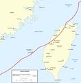
Figure 7. Surface-to-Air Missile Coverage over the Taiwan Strait.

Note: This map depicts notional coverage provided by China’s SA-10, SA-20 SAM systems, as well as the soon-to-be

acquired S-300PMU2. Actual coverage would be non-contiguous and dependent upon precise deployment sites.
Date 05/23/06
Source Image:China Report 2006.pdf
Author DoD
Permission
(Reusing this file)
Public domain
This image is a work of a U.S. military or Department of Defense employee, taken or made as part of that person's official duties. As a work of the U.S. federal government, the image is in the public domain in the United States.

العربية  català  čeština  Deutsch  Ελληνικά  English  español  eesti  فارسی  suomi  français  galego  हिन्दी  hrvatski  magyar  italiano  日本語  한국어  македонски  മലയാളം  Malti  Nederlands  polski  português  português do Brasil  română  русский  sicilianu  slovenčina  slovenščina  српски / srpski  ไทย  Türkçe  українська  Tiếng Việt  中文  中文(简体)  中文(繁體)  +/−

Other versions Derivative works of this file:  Surface-to-Air Missile Coverage over the Taiwan Strait-ar.png

Captions

Add a one-line explanation of what this file represents

Items portrayed in this file

depicts English

MIME type English

image/png

File history

Click on a date/time to view the file as it appeared at that time.

Date/TimeThumbnailDimensionsUsereComment
current22:15, 8 marte 2018Thumbnail for version as of 22:15, 8 marte 2018738 × 753 (104 KB)Ras67new extracted, cleaned and cropped from PDF
08:40, 26 maye 2006Thumbnail for version as of 08:40, 26 maye 2006769 × 773 (256 KB)Shizhao{{Information |Description=Figure 7. Surface-to-Air Missile Coverage over the Taiwan Strait. Note: This map depicts notional coverage provided by China’s SA-10, SA-20 SAM systems, as well as the soon-to-be acquired S-300PMU2. Actual coverage would be n

The following page uses this file:

Global file usage

Metadata